
Plik:NRC-regions-map.gif
Grafika w wyższej rozdzielczości nie jest dostępna.
NRC-regions-map.gif (550 × 415 pikseli, rozmiar pliku: 43 KB, typ MIME: image/gif)
| Plik NRC-regions-map.gif znajduje się w Wikimedia Commons – repozytorium wolnych zasobów. Dane z jego strony opisu znajdują się poniżej. |
Opis
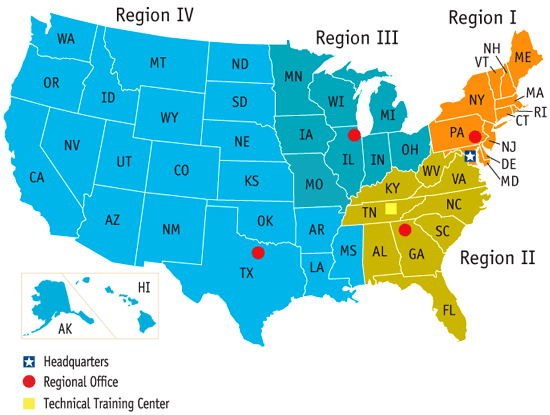
| Opis | Map of the United States by Nuclear Regulatory Commission (NRC) Region (Now shows Mississippi in Region 4, rather than 2.) |
| Data | Last revised prior to July 21, 2008 (previous: February 17, 2007) |
| Źródło | http://www.nrc.gov/images/info-finder/region-state/regions-map.gif |
| Autor | Nuclear Regulatory Commission |
| Licencja (Ponowne użycie tego pliku) |
"Information generated by the NRC or developed under an NRC contract is not copyrighted, unless indicated otherwise. Non-copyrighted material can be reproduced without permission; citation of the NRC as the source of the information is appreciated." |
Licencja
| This image is a work of a Nuclear Regulatory Commission employee, taken or made as part of that person's official duties. As a work of the U.S. federal government, the image is in the public domain in the United States. |
Historia pliku
Kliknij na datę/czas, aby zobaczyć, jak plik wyglądał w tym czasie.
| Data i czas | Miniatura | Wymiary | Użytkownik | Opis | |
|---|---|---|---|---|---|
| aktualny | 19:49, 21 lip 2008 | | 550 × 415 (43 KB) | Wwoods | |
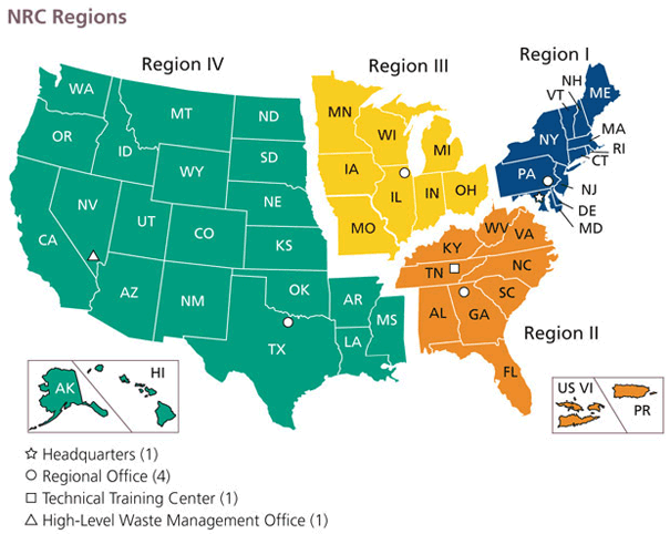
| 20:22, 12 sty 2007 |  | 560 × 350 (23 KB) | BigrTex | {{Information |Description=Map of the United States by Nuclear Regulatory Commission (NRC) Region |Source=http://www.nrc.gov/images/info-finder/region-state/regions-map.gif |Date=Last revised Tuesday, September 20, 2005 |Author=Nuclear Regulatory Commissi |
Lokalne wykorzystanie pliku
Poniższa strona korzysta z tego pliku:
Globalne wykorzystanie pliku
Ten plik jest wykorzystywany także w innych projektach wiki:
- Wykorzystanie na de.wikipedia.org
- Wykorzystanie na en.wikipedia.org
- Wykorzystanie na en.wikibooks.org
- Wykorzystanie na fr.wikipedia.org
- Wykorzystanie na ja.wikipedia.org
- Wykorzystanie na ko.wikipedia.org
- Wykorzystanie na zh.wikipedia.org