Plik:Hindu Kush satellite image.jpg

Treść strony nie jest dostępna w innych językach.
Ten plik jest umieszczony w Wikimedia Commons
Z Wikipedii, wolnej encyklopedii

Rozmiar pierwotny(5600 × 4400 pikseli, rozmiar pliku: 5,01 MB, typ MIME: image/jpeg)

Opis

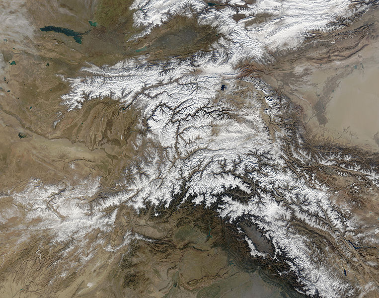
Opis The Hindu Kush occupies the lower-left-center of this true-color MODIS satellite image, acquired 28 November 2003.
Data
Źródło NASA's Earth Observatory
Autor Jeff Schmaltz, MODIS Land Rapid Response Team at NASA GSFC
Licencja
(Ponowne użycie tego pliku)
Public domain - original work of NASA
Inne wersje

Prace pochodne od tego pliku:  High Asia Mountain Ranges.jpg

Earth Observatory text: [1]

Once used by Alexander the Great in his effort to conquer the known world, the high-altitude passes of the Hindu Kush remain important trade and travel routes. Glaciers and heavy snowfall are ever-present features of these mountains, which rise to 7,692 meters (26,236 feet) in height.

Straddling the borders between Pakistan, Afghanistan, and India, the Hindu Kush is heavily populated. Though the valleys are heavily irrigated, growing crops at such high altitudes and low temperatures is difficult. The residents also have to worry about earthquakes, which are common as the Eurasian and Indo-Australian tectonic plates continue to push against one-another. This constant pressure and grinding create an average of four major (measuring at least 5 on the Richter scale) earthquakes a year.

In this true-color Terra Moderate Resolution Imaging Spectroradiometer (MODIS) image, the Hindu Kush occupies the lower-left-center of the image. To the left are the relatively lower altitude plains of southern Kazakhstan, Uzbekistan, Turkmenistan, Afghanistan, and Pakistan. The fertile plains surrounding the northern strands of the Indus River are a deep green at the bottom center of the image (a translucent veil of smog adds a gray tinge to the region). Straddling the mountains north of the Kush are Kyrgyzstan and Tajikistan, which butt up against the arid Tarim basin of northwestern China. The Silk Road, the all-important trade route between China and Europe, runs through the Hindu Kush and this basin. This true-color Terra MODIS image was acquired on November 28, 2003.

Image courtesy Jeff Schmaltz, MODIS Land Rapid Response Team at NASA GSFC

Licencja

Public domain Ten plik jest w domenie publicznej ponieważ został stworzony przez NASA. Polityka praw autorskich NASA stwierdza, że „materiały NASA nie są chronione prawami autorskimi, chyba że zapisano inaczej”. (NASA copyright policy lub JPL Image Use Policy).
Uwaga:
  • Użycie dowolnego ze znaków graficznych NASA jest ograniczone przez prawo w USA 14 CFR 1221.
  • Strony NASA udostępniają dużą liczbę zdjęć z radzieckiej, rosyjskiej, a także innych agencji kosmicznych. Nie muszą być one w domenie publicznej.
  • Materiały z Kosmicznego Teleskopu Hubble'a mogą być objęte prawami autorskimi jeśli nie pochodzą bezpośrednio ze Space Telescope Science Institute[2].
  • Wszystkie materiały powstałe w ramach działalności sondy SOHO są objęte prawami autorskimi i wymagają zgody na ich komercyjne i nieedukacyjne użycie[3].
  • Zdjęcia pojawiające się na stronie Astronomy Picture of the Day (Astronomiczne zdjęcie dnia) mogą być objęte prawem autorskim[4].

Podpisy

Dodaj jednolinijkowe objaśnienie tego, co ten plik pokazuje

Obiekty przedstawione na tym zdjęciu

przedstawia

Historia pliku

Kliknij na datę/czas, aby zobaczyć, jak plik wyglądał w tym czasie.

Data i czasMiniaturaWymiaryUżytkownikOpis
aktualny06:39, 6 cze 2006Miniatura wersji z 06:39, 6 cze 20065600 × 4400 (5,01 MB)Avenue{{Information |Description=The Hindu Kush occupies the lower-left-center of this true-color MODIS satellite image, acquired 28 November 2003. |Source=[NASA's Earth Observatory http://earthobservatory.nasa.gov/Newsroom/NewImages/images.php3?img_id=16411] |

Poniższa strona korzysta z tego pliku:

Globalne wykorzystanie pliku

Ten plik jest wykorzystywany także w innych projektach wiki:

Metadane