
Plik:Dalmazia1560.png
Dalmazia1560.png (516 × 424 pikseli, rozmiar pliku: 586 KB, typ MIME: image/png)
| Plik Dalmazia1560.png znajduje się w Wikimedia Commons – repozytorium wolnych zasobów. Dane z jego strony opisu znajdują się poniżej. |

Opis
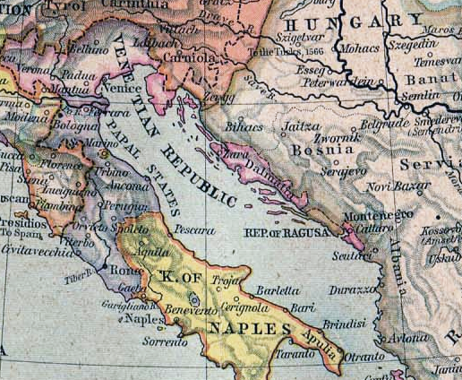
Map from "Historical Atlas" by William R. Shepherd, 1923
Licencja
|
Ten materiał przeszedł do domeny publicznej w kraju pochodzenia, jak również w państwach i terytoriach, gdzie prawo autorskie wygasa w ciągu 70 lat po śmierci autora.
| |
| Plik rozpoznano jako wolny od znanych ograniczeń praw autorskich, włącznie z prawami zależnymi i pokrewnymi. | |
Historia pliku
Kliknij na datę/czas, aby zobaczyć, jak plik wyglądał w tym czasie.
| Data i czas | Miniatura | Wymiary | Użytkownik | Opis | |
|---|---|---|---|---|---|
| aktualny | 23:14, 13 sie 2011 | | 516 × 424 (586 KB) | DIREKTOR | Tone |
| 22:40, 15 lut 2006 |  | 516 × 424 (549 KB) | Ilario | {{it|Istria e Dalmazia nel 1560}} Map from "Historical Atlas" by William R. Shepherd, 1923 Category:Maps of Dalmatia |
Lokalne wykorzystanie pliku
Poniższa strona korzysta z tego pliku:
Globalne wykorzystanie pliku
Ten plik jest wykorzystywany także w innych projektach wiki:
- Wykorzystanie na ast.wikipedia.org
- Wykorzystanie na cs.wikipedia.org
- Wykorzystanie na de.wikipedia.org
- Wykorzystanie na el.wikipedia.org
- Wykorzystanie na es.wikipedia.org
- Wykorzystanie na fa.wikipedia.org
- Wykorzystanie na he.wikipedia.org
- Wykorzystanie na hr.wikipedia.org
- Wykorzystanie na hu.wikipedia.org
- Wykorzystanie na hy.wikipedia.org
- Wykorzystanie na incubator.wikimedia.org
- Wykorzystanie na it.wikipedia.org
- Wykorzystanie na ja.wikipedia.org
- Wykorzystanie na lt.wikipedia.org
- Wykorzystanie na ms.wikipedia.org
- Wykorzystanie na nl.wikipedia.org
- Wykorzystanie na pt.wikipedia.org
- Wykorzystanie na ru.wikipedia.org
- Wykorzystanie na simple.wikipedia.org
- Wykorzystanie na sq.wikipedia.org
- Wykorzystanie na uk.wikipedia.org
- Wykorzystanie na vec.wikipedia.org