
Plik:Beaver wars map.jpg

Rozmiar podglądu – 710 × 600 pikseli. Inne rozdzielczości: 284 × 240 pikseli | 568 × 480 pikseli | 871 × 736 pikseli.
Rozmiar pierwotny (871 × 736 pikseli, rozmiar pliku: 163 KB, typ MIME: image/jpeg)
| Plik Beaver wars map.jpg znajduje się w Wikimedia Commons – repozytorium wolnych zasobów. Dane z jego strony opisu znajdują się poniżej. |
| Opis |
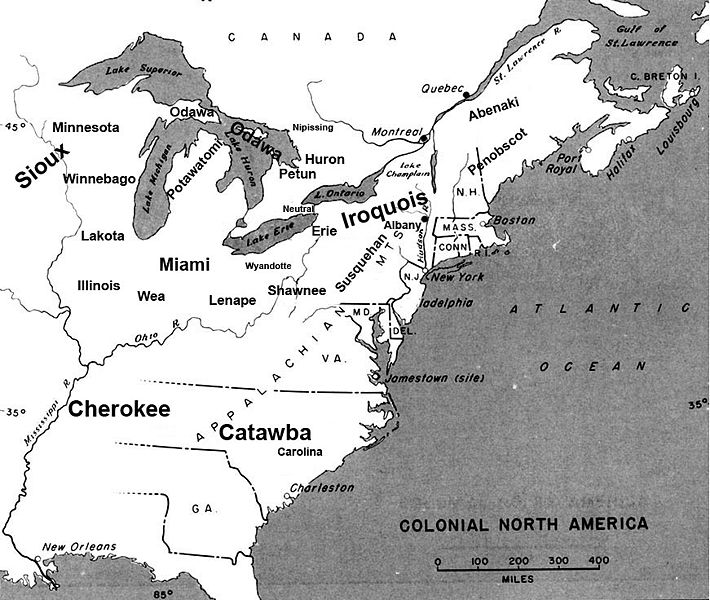
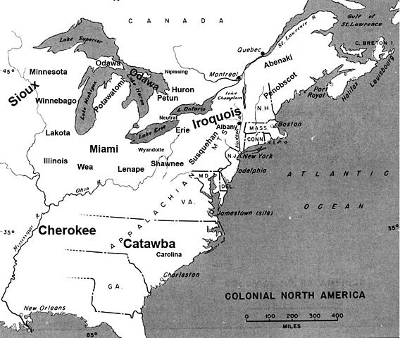
English: Map of the location of major tribes involved in the Beaver Wars laid against a period map showing colonial settlments |
||
| Data | |||
| Źródło | Praca własna | ||
| Autor | Charles Edward | ||
| Licencja (Ponowne użycie tego pliku) |
|
Info
This represents the approximate configuration of the tribes in 1648. Although the areas are large, the populations were low and large parts of the territories where uninhabited, and instead used as hunting grounds. The tribes were also semi nomadic, and the period was rife with war and several of the tribes on the map were destroyed in the 1650s. The map was made using information in several books incluing:
- Jennings, Francis (1984) The Ambiguous Iroquois Empire ISBN: 0393017192.
- Wallace, Paula W (2007) Indians in Pennsylvania, DIANE Publishing Inc ISBN: 1422314936.
Historia pliku
Kliknij na datę/czas, aby zobaczyć, jak plik wyglądał w tym czasie.
| Data i czas | Miniatura | Wymiary | Użytkownik | Opis | |
|---|---|---|---|---|---|
| aktualny | 00:34, 19 lis 2008 | | 871 × 736 (163 KB) | Charles Edward | Slight adjustment to name on image |
| 00:33, 19 lis 2008 |  | 871 × 736 (164 KB) | Charles Edward | {{Information |Description=adjustment of locations per discussion on Beaver War talk page |Source= |Date= |Author= |Permission= |other_versions= }} | |
| 21:51, 16 lis 2008 |  | 871 × 736 (298 KB) | Charles Edward | {{Information |Description=New version removes borders, ads more ambiguity to the map |Source= |Date= |Author= |Permission= |other_versions= }} | |
| 04:43, 16 lis 2008 |  | 815 × 472 (275 KB) | Charles Edward | {{Information |Description= |Source= |Date= |Author= |Permission= |other_versions= }} | |
| 03:16, 16 lis 2008 |  | 815 × 472 (275 KB) | Charles Edward | {{Information |Description=adding tribes, adjusting locations |Source= |Date= |Author= |Permission= |other_versions= }} Category:Maps of the United States | |
| 02:39, 16 lis 2008 |  | 815 × 472 (270 KB) | Charles Edward | {{Information |Description=Added additional tribes |Source= |Date= |Author= |Permission= |other_versions= }} | |
| 02:35, 16 lis 2008 |  | 815 × 472 (270 KB) | Charles Edward | {{Information |Description=Added additional tribes |Source= |Date= |Author= |Permission= |other_versions= }} | |
| 02:14, 16 lis 2008 |  | 815 × 472 (262 KB) | Charles Edward | {{Information |Description={{en|1=Map of the location of major tribes involved in the Beaver Wars laid against a period map showing colonial settlments}} |Source=Own work by uploader |Author=Charles Edward |Date=11-15-8 |Permission |
Lokalne wykorzystanie pliku
Następujące strony korzystają z tego pliku:
Globalne wykorzystanie pliku
Ten plik jest wykorzystywany także w innych projektach wiki:
- Wykorzystanie na azb.wikipedia.org
- Wykorzystanie na cs.wikipedia.org
- Wykorzystanie na en.wikipedia.org
- Wykorzystanie na es.wikipedia.org
- Wykorzystanie na et.wikipedia.org
- Wykorzystanie na gl.wikipedia.org
- Wykorzystanie na id.wikipedia.org
- Wykorzystanie na it.wikipedia.org
- Wykorzystanie na ja.wikipedia.org
- Wykorzystanie na lv.wikipedia.org
- Wykorzystanie na nl.wikipedia.org
- Wykorzystanie na no.wikipedia.org